

.png)
Rongai Gate - Simba Camp - Mawenzi Tarn - Uhuru Peak
6 Days Kilimanjaro Rongai Route
Introduction
The Rongai Route is the only route that approaches Kilimanjaro from the north, starting near the Kenyan border. This remote and less-travelled path offers a true wilderness experience, distinct from the busier southern routes. As you trek across the mountain's northern slopes, you will be rewarded with breathtaking views of the Kenyan plains, the rugged Mawenzi peak, and an unforgettable summit night ascent to Uhuru Peak. This 6-day itinerary is designed for adventurers seeking a quieter, more intimate Kilimanjaro experience with a high wilderness feel.
Why Choose the Rongai Route?
Only Northern Approach
The Rongai Route is the sole Kilimanjaro route starting from the north, near the Kenya-Tanzania border. This unique approach offers perspectives no other route can match.
Less Crowded
Far fewer climbers choose Rongai compared to Machame or Marangu. Enjoy a quieter, more solitary wilderness experience on the mountain.
Remote Wilderness
Trek through pristine montane forest, heath, and alpine desert with minimal human impact. The northern side feels wild and untouched.
Gentle Ascent Profile
The Rongai Route features a gradual climb through its early stages, making it slightly easier on the legs before the steeper sections higher up.
High Success Rate
The northern approach combined with a steady ascent contributes to a strong summit success rate among well-prepared climbers.
Unique Perspective
See Kilimanjaro from angles few visitors experience. The northern face, Mawenzi up close, and sweeping views across the Kenyan savannah.
Tour Highlights
- Summit Uhuru Peak - Stand at the Roof of Africa (5,895m)
- Northern Approach - The only route from the Kenyan border
- Remote Wilderness - Trek the quiet, wild northern slopes
- Stunning Sunrises - Watch the sun rise over the African plains
- Saddle Crossing - Traverse the lunar landscape between Mawenzi and Kibo
- Mawenzi Views - Get up close to Kilimanjaro's rugged second peak
- Forest Descent - Descend through lush rainforest on the Marangu Route
- Expert Guides - Experienced, certified mountain guides throughout
Detailed Itinerary
Each day is carefully planned to maximise acclimatisation and enjoyment. Below you will find a complete breakdown of every stage, from the Rongai Gate to the summit and descent.
Rongai Gate (1,950m) to Simba Camp (2,600m)
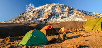
After breakfast in Moshi, drive approximately 3 hours to the Rongai Gate (1,950m) on the northeastern side of Kilimanjaro, close to the Kenyan border. After registration with park authorities, begin your trek through dense pine forest on a gentle, well-defined trail. The path winds through stands of giant heather and podocarpus trees as you ascend steadily. Arrive at Simba Camp (2,600m) in the late afternoon, where your tents are already set up. Enjoy dinner prepared by your mountain chef and watch the sunset over the Kenyan plains.
Simba Camp (2,600m) to Second Cave (3,500m)
Wake to a clear morning on the northern slopes. After breakfast, the trail leaves the forest behind and enters open heath and moorland. The vegetation transitions to giant lobelias, senecios, and heather as you climb. The views of the Kenyan plains to the north are spectacular throughout the day. The trail passes the First Cave (a small overhang used by climbers in wet weather) before reaching Second Cave (3,500m), a large rock shelter and your camp for the night.
Second Cave (3,500m) to Kikelwa Camp (3,650m)
A relatively short but scenic day designed for gradual acclimatisation. The trail continues across the northern slopes, traversing moorland and alpine desert. You will pass the Third Cave (often used as an alternative camp) before descending slightly into the Kikelwa valley. Kikelwa Camp is nestled in a sheltered valley with views of the Kenyan border.
Kikelwa Camp (3,650m) to Mawenzi Tarn Camp (4,330m)
A challenging but rewarding day as you climb to the foot of the magnificent Mawenzi peak. The terrain becomes more rugged and rocky as you leave the moorland behind and enter true alpine desert. The views of Mawenzi's jagged ridges are breathtaking. Mawenzi Tarn Camp sits beside a small glacial lake at the base of the Mawenzi cliffs - one of Kilimanjaro's most spectacular camping locations.
Mawenzi Tarn (4,330m) to Kibo Hut (4,700m) & Midnight Summit Prep
Today you cross the famous saddle - the high-altitude desert between Mawenzi and Kibo. This lunar landscape is exposed and dramatic, with loose volcanic scree underfoot. Arrive at Kibo Hut (4,700m) in the early afternoon. After a hot meal, you will rest and prepare for the midnight summit attempt. The summit push begins at 11:30 PM, ascending by headlamp through the night to reach Uhuru Peak at sunrise.
SUMMIT: Kibo Hut (4,700m) to Uhuru Peak (5,895m) — Descent to Marangu Gate & Arusha
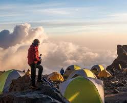
Summit night is the most challenging yet rewarding part of your Kilimanjaro journey. Starting at midnight from Kibo Hut (4,700m), you ascend by headlamp in single file, climbing steep switchbacks up volcanic scree to the crater rim at Gilman's Point (5,681m). From there, traverse the crater rim to Uhuru Peak (5,895m) — the highest point in Africa. After sunrise celebration and photos, descend back to Kibo Hut for a brief rest, then continue down through the Marangu Route to Horombo Hut and eventually to Marangu Gate, where your vehicle awaits to transfer you to Arusha.
Destinations You'll Explore
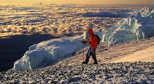
Kilimanjaro National Park
A UNESCO World Heritage Site spanning five distinct ecological zones from montane forest to arctic summit. Kilimanjaro is Africa's highest peak and the world's tallest free-standing mountain.
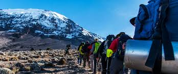
Rongai Route
The only northern approach to Kilimanjaro, starting near the Kenyan border. Remote, uncrowded, and offering a true wilderness trekking experience through pristine mountain landscapes.
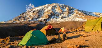
Marangu Descent
After summiting, you descend via the Marangu Route, passing through Horombo Hut and the lush montane forest to Marangu Gate. This path offers a different perspective of the mountain.
| Included |
|
|---|---|
| Excluded |
|
| Transport |
|
Photo Gallery
Rongai Approach TrailMawenzi Peak View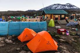 Simba Camp
 Summit Sunrise
 Northern SlopesKilimanjaro Mountain
Location
What Our Climbers Say
Join thousands of satisfied climbers who have reached the Roof of Africa with us.
Frequently Asked Questions
What makes the Rongai Route different from other Kilimanjaro routes?
Rongai is the only route that approaches Kilimanjaro from the north, starting near the Kenyan border. It is the least crowded route, offering a remote wilderness experience with unique views of the mountain's northern face and the Kenyan plains. Unlike the busy Machame or Marangu routes, you will trek in relative solitude.
How difficult is the 6-day Rongai Route climb?
The Rongai Route is considered demanding but has a gentler ascent profile than many other routes. The 6-day itinerary is challenging due to the shorter acclimatisation period compared to 7 or 8-day options. Good physical fitness, cardiovascular endurance, and prior trekking experience are recommended for success.
What is the best time to climb via the Rongai Route?
The best times are the dry seasons: January to March and June to October. The Rongai Route receives less rainfall than the southern routes because it lies in the rain shadow of Kilimanjaro, making it a good choice during the shoulder seasons (November-December and April-May).
Does the Rongai Route start near the Kenya border?
Yes, the Rongai Route begins at the Rongai Gate on the northern side of Kilimanjaro, very close to the Kenya-Tanzania border. This remote starting point offers a unique perspective of the mountain and requires a longer drive from Moshi than other routes.
What fitness level is required for the Rongai Route?
A good level of fitness is essential. You should be comfortable walking for 5-7 hours daily at altitude, sometimes on steep or rocky terrain. Cardiovascular training, regular hiking with a loaded daypack (10-15 kg), and stair climbing are strongly recommended preparation.
How does altitude sickness affect climbers on the Rongai Route?
Altitude sickness (AMS) can affect anyone regardless of age, fitness, or experience. The Rongai Route has a gentler ascent than some routes but still reaches 5,895m. Symptoms include headache, nausea, dizziness, and fatigue. Proper acclimatisation, hydration, and a slow pace (pole pole) are essential. Our guides are trained to monitor and manage AMS.
What should I pack for a Rongai Route climb?
Pack layered clothing (base layer, mid-layer, insulated jacket), a waterproof/windproof outer jacket and trousers, sturdy waterproof hiking boots, gaiters, trekking poles, a warm sleeping bag (rated to -15C or lower), headlamp with spare batteries, sunscreen (SPF 50+), sunglasses, water bottles or hydration bladder (3L capacity), high-energy snacks, and personal medication.
What is the minimum age for climbing Kilimanjaro via Rongai?
The official minimum age for climbing Kilimanjaro is 10 years old. However, we recommend the Rongai Route for climbers aged 12 and above due to the remote terrain, longer trekking days, and altitude demands. Prior hiking experience is essential for younger climbers.
What is the typical group size for the Rongai Route?
Our groups typically range from 2 to 12 climbers. The crew-to-climber ratio is generous: you will have one lead guide, one assistant guide per 4 climbers, and approximately 2 porters per climber. Private climbs for solo travellers or small groups can also be arranged.
What is the tipping policy for guides and porters?
Tipping is customary and greatly appreciated. Recommended amounts: $20-30 per day for the lead guide, $15-20 per day for assistant guides, and $8-12 per day for porters and cooks. Tips are typically pooled and distributed at the end of the trek during a farewell ceremony.
What park fees are included in the Rongai Route package?
Our package includes all Kilimanjaro National Park entry fees, camping fees, rescue fees, value-added tax, and government levies. There are no hidden charges for park access. The fees also contribute to conservation efforts and local community projects.
What is the weather like on the Rongai Route?
The Rongai Route is generally drier than the southern routes as it lies in Kilimanjaro's rain shadow. Temperatures range from 25C (77F) at the starting gate to below freezing at the summit. The northern side experiences less precipitation, but summit night can be extremely cold (-10 to -20C) with strong winds.
Do I receive a certification after summiting Kilimanjaro?
Yes, all climbers who reach the summit receive an official certificate from Kilimanjaro National Park. You receive a gold certificate for reaching Uhuru Peak (5,895m) or a green certificate for reaching Gilman's Point (5,681m). Both are signed by park authorities and are treasured souvenirs.
What facilities are available at Simba Camp?
Simba Camp (2,600m) is a basic wilderness camp with pit toilet facilities and designated tent platforms. There are no permanent buildings, running water, or electricity. Your crew sets up private expedition tents with sleeping mats. All meals are cooked fresh by your mountain chef using locally sourced ingredients.
What should I expect during summit night?
Summit night begins around midnight from Kibo Hut (4,700m). You ascend in darkness using only headlamps, climbing steeply for 6-8 hours to reach the crater rim. The terrain is steep volcanic scree. Temperatures drop to -10 to -20C with strong winds. You will be walking in a single-file line, setting an extremely slow pace. Reaching Gilman's Point at sunrise is an emotional and unforgettable experience. From there, you continue along the crater rim to Uhuru Peak.
Ready to Climb Kilimanjaro via the Rongai Route?
Book your 6-day wilderness adventure on the northern slopes of Africa's highest peak.